
Today was a significantly cooler day, and windy conditions made the temperature feel even colder. Highs only made it to the low 40s, but temperatures felt like near freezing with wind chills in the low 30s. Cool temperatures and windy conditions look to continue for Wednesday and Thursday.
Tonight:
Mostly cloudy skies continue tonight with slight clearing. Temperatures will fall to around 30 degrees. Winds will continue to be breezy at 12-18 mph from the west with gusts over 30 mph. Temperatures will feel like the low 20s with the windy conditions.
Tomorrow:
Wednesday will be similar to today with even more wind. The National Weather Service has issued a wind Advisory for the area from 6 am to 4 pm. Winds will be from the west at 20-25 mph with gusts as high as 45 mph. High temperatures will be around 40 degrees, but with the wind chill, temperatures will feel below freezing for the entire day. In the evening, west winds will die down slightly to 12-18 mph with gusts as high as 35 mph. The skies will become mostly clear, and temperatures will fall to around 30 degrees again with the wind chill in the mid 20s.
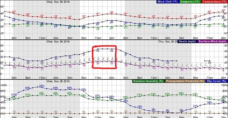
This image shows the 48 hours prediction chart for College Park from the National Weather Service. Winds will peak between 11am-2pm at around 22 mph with gusts 45. Wind chills will fall to the mid to lower 20s tonight and tomorrow night. Cloud cover also remains mostly cloudy through Wednesday afternoon becoming almost clear by Wednesday night.
Thursday and Beyond:
Thursday will bring mostly sunny skies with less windy conditions, but still noticeable west winds around 10 mph. High temperatures will continue to be in the low 40s. Clouds will begin to develop, becoming mostly cloudy by evening with showers arriving late Thursday night or early Friday Morning. The weekend right now is looking warmer, but wetter. Stay tuned for more updates as the weekend approaches.