
Today was another cool sunny day as high temperatures reached around 60 today. That is around 5 degrees cooler than average for October 30th. Tomorrow on Halloween, temperature warm to slightly above average making tomorrow perfect for any festivities throughout the day and night.
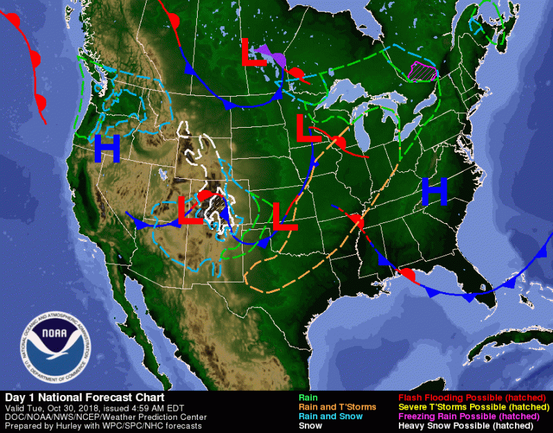
This image from NOAA WPC shows today’s weather across the Contiguous United States. The high pressure over the Carolinas will give the DMV warm south wind that will lead to higher than average temperatures over the next couple of days.
Tonight:
Mostly clear skies will continue to allow temperatures to fall into the mid-40s. Winds will be calm and variable. Tonight will be a good night have any All Hallows Eve Eve’s activities in preparation for Halloween.
Tomorrow (Wednesday):
Halloween will start sunny with few clouds and south winds at 5 to 9 mph will bring temperatures to the upper 60s. Clouds will begin developing by evening as a cold front begins to approach the area. Lows only fall into the mid 50s as southwest winds at 7-9 mph continue to blow warm air in. The moon phase will be in its last quarter as the full moon was last Wednesday, so no worries about werewolves tomorrow.
Thursday and a Look Ahead:
Thursday will start partly sunny and even warmer with highs in the low 70s. South winds will increase to 7-14 mph with gusts over 20 mph. Clouds will continue to build up, making the sky mostly cloudy by evening. Rain will start late Thursday evening keeping lows warm (in the low 60s) with southerly winds at 5-10 mph. Friday showers continue, but will lighten throughout the day as highs rise to the upper 60s and fall to the low 40s. Winds will shift from south to from the north keeping the DMV cool, but clearer Saturday.

This image from Tropical Tidbits shows the GFS model run earlier today that predicts showers arriving by 2 am Friday. Stay tuned tomorrow on updates on when the rain arrives to the DMV.