
Temperatures today topping out in the mid 60s were just a couple degrees shy of the average high. Skies remained sunny as a cold front passed through this afternoon. Winds have been steady out of the northwest at 15 mph with gusts up to 35 mph.
Tonight:
Skies will remain mostly clear tonight and that will allow the temperatures to drop rapidly overnight into the low 40s. There will be a northwest wind around 10 mph with gusts up to 20 mph.
Tomorrow (Thursday):
Skies will be sunny, but the temperature will be slow to rise, only making it to the mid 50s tomorrow afternoon. Temperatures will be running about 10-15 degrees below average, more what you would expect for late November. There will be a northwest breeze around 10 mph.
Tomorrow Night:
Temperatures will drop rapidly again thanks to the clear skies and low humidity. Lows are expected to be in the upper 30s for the first time since April. Winds will be light and variable.
A Look Ahead:
The weekend will start out a bit warmer, with temperatures back in the 60s for highs, and lows in the 40s and 50s for Friday and Saturday. Sunday will be very cool again with a small chance of some patchy frost possible by Sunday night. The next few weeks will feature more rounds of near-seasonable temperatures followed by well below average temperatures. The chilly temperatures are likely to stick around right through the end of the month into the beginning of November.
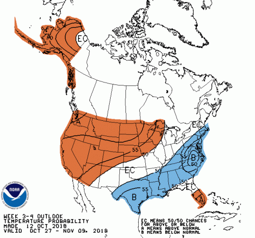
The week 3-4 forecast for the end of October into the beginning of November has the area with near a 60% chance of below average temperatures. Courtesy of noaa.gov
Featured Image via pixabay.com