
On the last day of classes before Homecoming weekend the weather has taken a dramatic turn in comparison to the past several weeks. Temperatures this afternoon are hovering right around the low to mid 60s under mostly sunny skies. The combination of low humidity with dew points in the low 40s and a northwest breeze around 15 mph with gusts up to 25 mph is making it finally feel cool outside.
Tonight:
This will be the first night in the 40s since the spring! Temperatures will drop this evening bottoming out in the upper 40s overnight. Clouds will begin to increase late as a weak low pressure system passes to the north. The chance of rain overnight is 40% with a few showers possible. Winds will be out of the northwest around 5-10 mph.
Tomorrow (Saturday):
The morning will start out mostly cloudy with still about a 30% chance of showers in the morning. By mid-morning those clouds begin to break, and it will be partly to mostly sunny by kickoff at 12 p.m. for the Homecoming football game. Temperatures will top out around 60 degrees with winds out of the west around 10 mph with gusts up to 20 mph.
Tomorrow Night:
Skies will be mostly clear tomorrow night with a northwest breeze around 5 mph. Temperatures will drop into the mid 40s.
A Look Ahead::
Sunday features another cool day, but it will be mostly sunny. Clouds increase with some showers possible Monday as temperatures rebound to near 70 degrees for the high temperature. By Tuesday the cooler temperatures return, and that will be the theme for at least the next 10 days. Below average temperatures are favored for the region for the next one to two weeks.
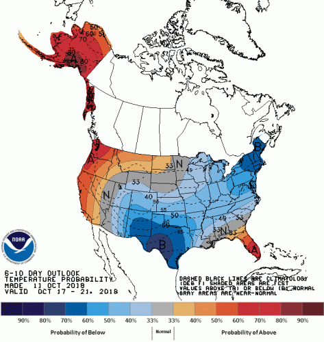
Odds favor a greater than 50% chance of below average temperatures for our region for the 6-10 day period. Image courtesy of noaa.gov
Featured image via pixabay.com