
The wet weather continued today as remnants of Florence passed by. After a tornado watch yesterday and heavy rain, the next few days are going to be the break we need from all this rain.
How much Rain did we get?

This image from the Advanced Hydrologic Prediction Service shows the rainfall in the past week. Many locations in the Metro D.C area have received more rain this week, most of it came the past couple of days, than our average rainfall for the entire month of September.
College Park and other local areas have received more rain than their average rainfall for entire month of September. Year to date we are around 12 to 16 inches above the average rain fall year to date. Fortunately, we going to get at least a few days without rain.
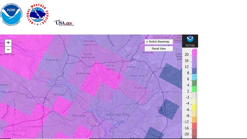
This image from the Advanced Hydrologic Prediction Service shows the rainfall departure year to date for the Metro D.C area. College Park shows a departure of between 12-16 in above average.
Tonight:
Mostly cloudy skies will continue as will scattered showers and thunderstorms, especially South of College Park. As the evening continues, the chance of rain diminishes and clouds will start to lessen. Lows will fall to the upper 60s with Northwest winds at 6-10 mph.
Tomorrow (Wednesday):
Mostly clear skies with abundant sunshine and no rain as temperatures rise into low to mid 80s. Winds will shift to be coming from the North at 7-9 mph. Tomorrow evening will continue to be mostly clear allowing temperatures to fall to the mid-60s with Northwest wind at 3-6 mph.
The Rest of the Week:
Mostly sunny skies will continue to be present through Friday with highs in the low to mid 80s and lows in the mid to upper 60s. The next chance of rain might be Saturday. Enjoy the Sunshine.
Featured image via Pixabay.com