Terps should be trekking along with rain jackets and umbrellas in tow today and tomorrow as pesky passing showers keep us on our toes. Temperatures will only reach the upper 70s but high humidity lingers to give us a headache through the weekend. Still, we should feel lucky we only catch the outermost bands of moisture from Ms. Florence as she wreaks most her havoc on the Southeast.
Tonight:
Prepare for your toes to get splashed as you step out on the town tonight. A persistent easterly flow sets up, driving in ample moisture to fuel clouds and scattered showers through the night. The mist and overcast skies at least will help keep things slightly cooler as temperatures dip in into the low 70s. However, a general mugginess will tag along to your Friday night plans, causing your hair to frizz in protest. Wind gusts coming in on the tails of Florence could provide temporary relief to this problem, but overall sustained winds should die down to around 10 mph by tonight. Honestly, this weather makes you wonder when the Dementors are going to leave their dreary reign over College Park, Maryland and the answer is not for a few more days, folks.

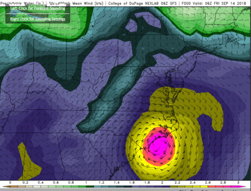
A depiction of the available moisture into tonight as a result of some of the outer rain bands of Florence. This influence should slowly die out tomorrow, at least temporarily. (via GFS on https://weather.cod.edu/forecast/ )
Tomorrow (Can Someone Say SATURDAY!):
The football game should go off without a hitch, but that’s not to say a pop-up shower or two won’t throw itself into the mix by fourth quarter and into the evening. After all, high humidity continues to chug along and easterly winds persevere around 9mph, but Florence will tentatively release her grip of funneling in moisture to Maryland as she channels farther inland. Check back though to see what role her remnants could play by Monday. Make sure to hydrate as high temperatures could creep into the low 80s by late afternoon, reminding us that a ridge of high pressure is still very much intact over the Northeast and upper Mid-Atlantic.

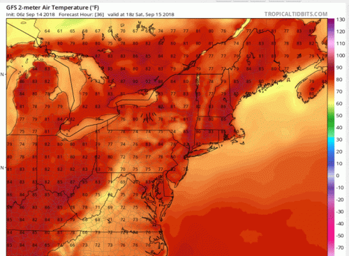
Temperatures start to heat up again into the low 80s tomorrow afternoon, exacerbated by high humidity. (via GFS)
