Hurricane Florence is now a category 2 hurricane, but remains a large and powerful storm as it approaches the east coast. Yesterday there were 84 foot waves reported in the northeastern quadrant, quite impressive even for a tropical system! Florence will remain a major hurricane upon its approach and the edge of the hurricane will reach the Carolina coast tomorrow morning. Due to its huge wind field, a large storm surge is expected to push water toward the coast in the northwest quadrant.
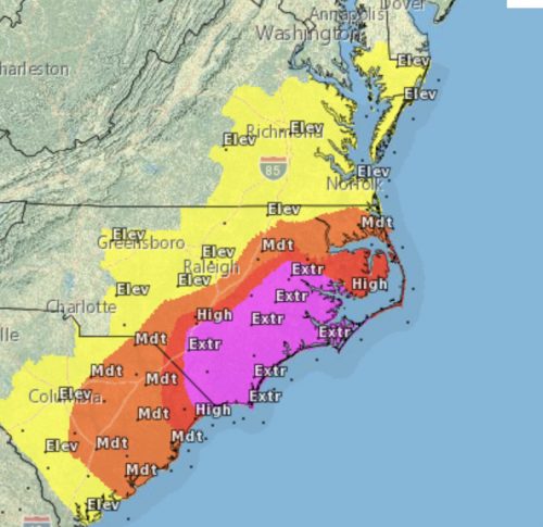
Florence is likely to stall just before or after a landfall in southeast North Carolina. The slow movement of the system will result in copious rainfall amounts, possibly exceeding in 20 inches in just two days. While it is unknown where Florence will stall, there is high confidence in excessive, possibly historic rainfall amounts. This weekend Florence will slowly move inland and begin to weaken, but rain and gusty winds are still potential hazards.

The risk of excessive rainfall over the next few days shows the extreme level of concern for the North Carolina coast. Image courtesy of www.weather.gov/akq/Florence
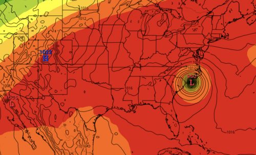
The path of Florence is very complicated and some impacts down the line may still be felt in Maryland. A ridge of high pressure to the east of Florence has been pushing her toward the coast. This ridge is weakening, while a ridge to the west is attempting to pull the hurricane south. An upper level low near Florida is expected to pull Florence to the east, all at the same time, explaining the stationary motion predicted.

The 500mb height map shows ridging trapping Florence along the Mid Atlantic coast. Image courtesy of tropicaltidbits.com
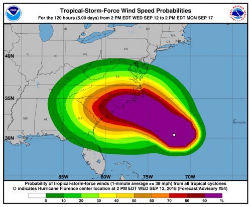
If Florence reaches Maryland, the timeframe will be late this weekend or early next week as a tropical storm. Currently it is hard to say if the system will track across Maryland, but more rainfall and gusty winds would be possible. Any additional rainfall could be a hazard with the very saturated soil in place.

The forecast for tropical-force wind speeds for Florence keeps College Park right on the edge. Image courtesy of www.weather.gov/akq/Florence
