
For the second time within a week, a developing Nor’easter off the northeast coast will bring whiteout conditions and gusty winds to most of New England. The DMV will generally be safe from meaningful accumulation this round, but the chances of sticking snowfall increase as we trek north. Locales north and east of Baltimore are under Winter Weather Advisories as we speak. This won’t rule out some snowflakes in our area between when you read this and the end of tomorrow.
Through Tonight:
The thick blanket of clouds is here to stay, as a slushy mix of rain and snow, aided by above freezing temperatures, will fill in around midnight. Snow might mix in with rain before transitioning to all rain after midnight as the rain-snow line pushes north. Expect no snow accumulation as many surfaces will be too warm for snow to stick. Light winds will be blowing from the southeast.
Tomorrow (Wednesday):
Expect primarily rain to persist throughout the day tomorrow, with a possibility of snow mixed in during the morning commute. Don’t forget the umbrella as steady showers are expected to continue throughout the day and linger into the late afternoon. Temperatures will rise around the mid 40s as light southerly winds shift to the northwest and become increasingly blustery, with gusts possible in the afternoon. Stay tuned to UMD weather for any changes, as the snowfall amounts with Nor’easters depends greatly on the position and track of the system.
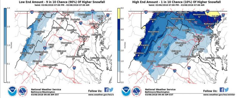
Low and high end snowfall forecasts for the DMV area (via NWS/NOAA).
Feature photo courtesy of Sioux City Journal.