
Meteorological Winter starts on December 1st and that means it’s time for our first annual Winter Outlook. Last winter was a dud and ranked among one of the warmest in Maryland. This also led to very little chances for snow (only 3.4 inches in D.C.) and many disappointed winter lovers. It won’t be hard for this winter to be colder and snowier, but we believe this will be the case. Now let’s get right to it with our national outlook followed by a closer look at Maryland.
National Outlook
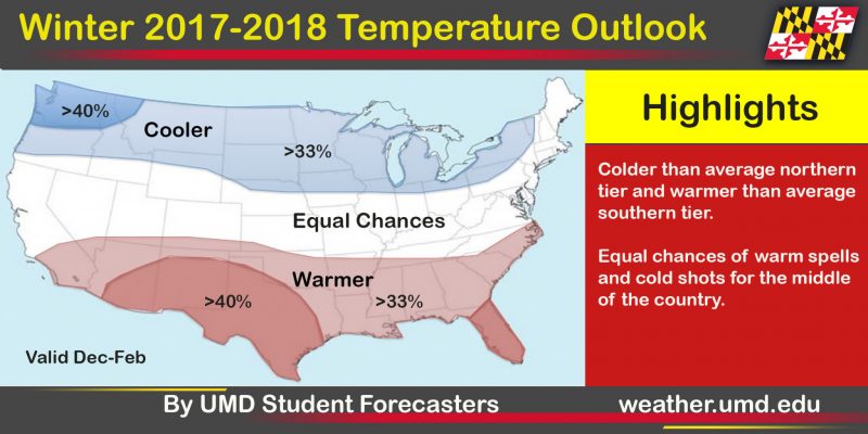
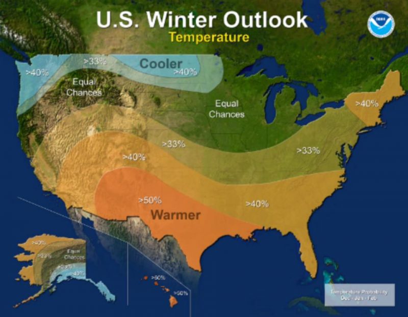
Temperature outlook relative to normal. Blue = Colder than average temperatures and Red = Warmer than average temperatures.
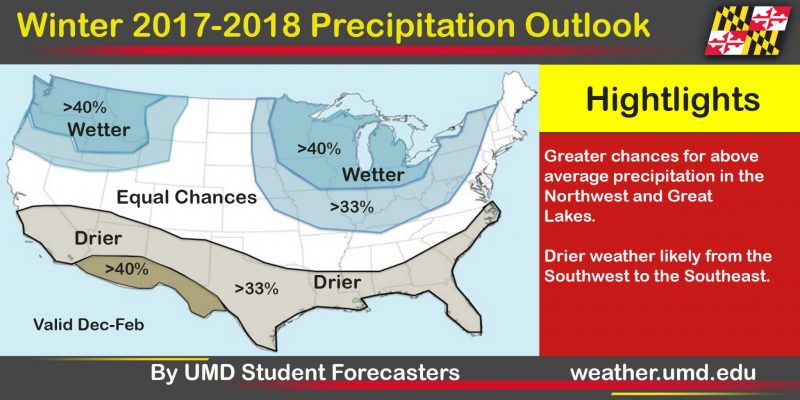
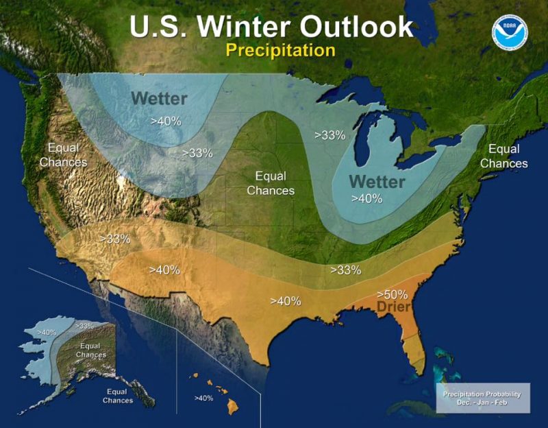
Precipitation outlook relative to normal. Blue = wetter than average weather and Brown = drier than average weather.
What about Maryland?
You can tell from the national outlook above that we expect Maryland to have equal chances of above and below average temperatures this winter. You can also see we expect western Maryland to have a >33% chance of seeing a wetter than average winter, while the rest of Maryland has equal chances at seeing above and below average precipitation. Below is our snowfall outlook for the state of Maryland.
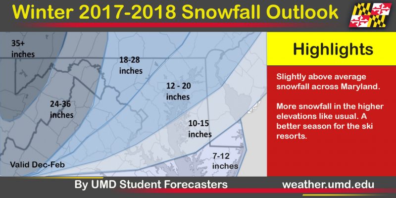
This forecast is valid from December 1st through February 28th (meteorological winter). Snow can also fall before or after this period.
Reasoning
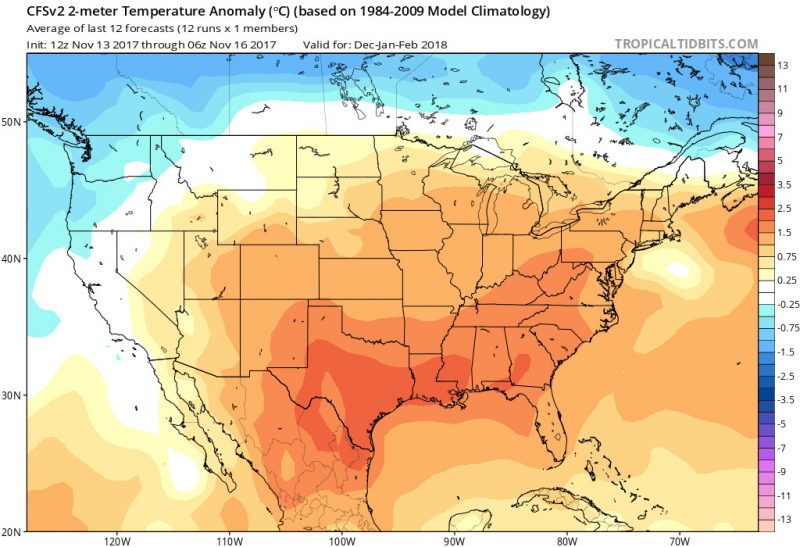
A big factor this winter will be the La Niña that has developed in the central and eastern Pacific. Details on what specifically it means for Maryland can be found in one of our previous articles here. Since these conditions usually lead to colder than average temperatures for the northern U.S. and warmer than average temperatures for the southern U.S., that is what you see in our temperature outlook. This can also be modeled with a the CFSv2 climate model. Here, temperatures are warmer than normal across much of the northern half of the lower 48, but the south appears to be warmer than the north according to the CFSv2 model. Note: this model tends to forecast temperatures slightly warmer than what actually happens.
Our precipitation outlook follows the same La Niña look as the jet stream will predominately be located across the middle of the country and not dig deep into the southern states as much as usual. This would cause drier weather in the southern states and more low-pressure systems to propagate in the central and northern U.S. This can be modeled again by the CFSv2 and actually agrees with the La Niña pattern as well as our thinking.

This all leads us to our reasoning for our snowfall outlook. Since we are predicting about average temperatures and average to slightly above average precipitation, it is important to know what exactly is the average snowfall here. Our friends at the National Weather Service in Sterling, Virginia shared this awesome image of what the average snowfall is in the Maryland area.
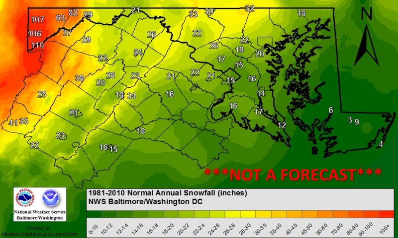
Average snowfall via NWS DC/BALT
What about ice storms?
Another not-so-popular winter hazard are ice storms. Last year we saw first hand with two ice storms that impacted travel in the morning hours. Carly Kovacik of the Southern Climate Impacts Planning Program and the University of Oklahoma found an interesting correlation that shows Maryland sees more ice storms during a La Niña. This will be something to watch a hope against it happening throughout the winter months. Hopefully our streets do not turn into an ice rink too often!
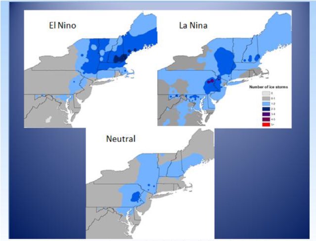
Differences in frequencies of ice storms relative to the ENSO cycle. The entire paper can be found here.
What are others saying?
The Climate Prediction Center (CPC) branch of NOAA:
Capital Weather Gang:
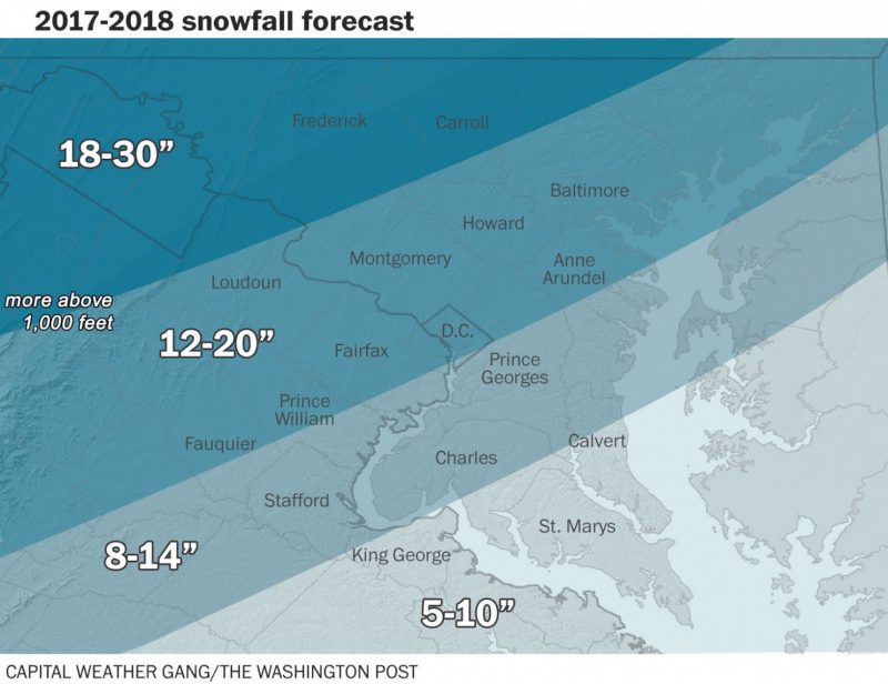
Click here for their full forecast.
NBC4 Washington:
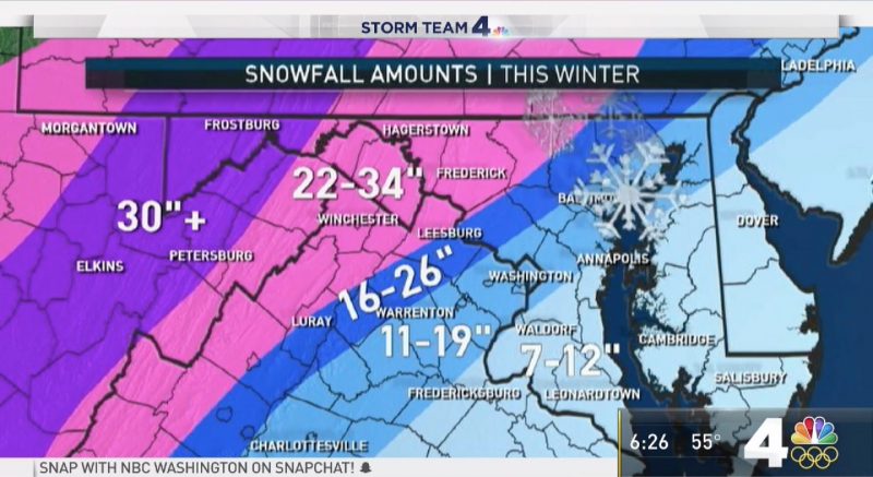
Click here for their full forecast.
FOX5 DC:
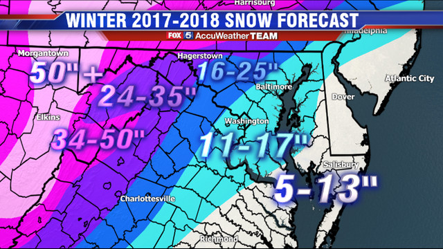
Their full forecast here.
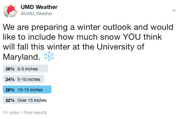
Our Twitter poll:
At the end of the day, long-range forecasts like these are extremely difficult to do. This is a low-confidence forecast that is subject to evolve throughout the season, as our chaotic atmosphere is always changing and misbehaving in ways we cannot yet predict or understand. Many variables can affect weather over a season’s length, but whether there’s an El Niño or La Niña is usually one of the biggest culprits, especially in winter.
Also, this is a seasonal forecast. For example, having a colder than average winter could not rule out a series of days in the middle of January where we see T-shirt weather with temperatures in the upper 60s.
Overall, we do think this winter will make ski and snowboard enthusiasts happier than last year.
Thanks for reading! If you have any comments or questions be sure to follow us on Facebook and Twitter.
Contributions to this post made by Keenan Eure.