
A warmer than normal autumn day helped dry out the rain associated with a cold front that moved through last night. Continue to expect sunny weather in the coming days as cooler air moves into Maryland, bringing more fall-like temperatures.
Tonight
Tonight is expected to be a lot cooler compared to last night with low temperatures dropping into the low 50s and upper 40s for the northern suburbs. Light winds will be blowing from the southwest before becoming northwest after midnight. Partly to mostly cloudy skies will obscure the night sky, but no precipitation is expected.
Tomorrow (Wednesday)
Similar to Tuesday, expect partly to mostly cloudy skies with a few breaks of sunshine tomorrow. However, light winds blowing from the northwest will result in cooler and more seasonal temperatures. Highs will reach the low-to-mid 60s. A sweatshirt will be needed in the evening as temperatures will drop into the 40s.
Elsewhere
After battering Japan, former Super Typhoon Lan has undergone an extratropical transition and strengthened to a very strong extratropical cyclone. This storm is currently churning in the Bering Sea and bringing hurricane force gusts to portions of the Aleutian Islands with towering waves exceeding 60 feet. Weather models estimate that the central pressure of this storm is around 935 mb, which is lower than Hurricane Jose at peak intensity this year. This massive system is going to be partly responsible for an active weather pattern over the United States through the next few weeks.
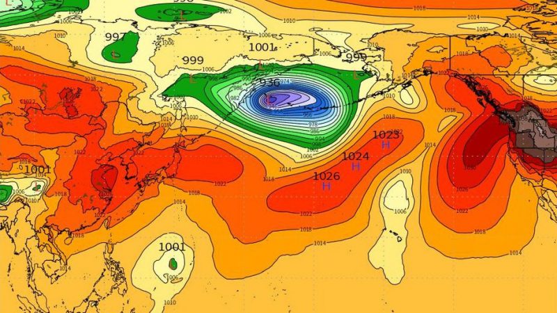
Image showing the very strong low pressure system in the northern Pacific. (Via Mashable)
Featured image via the editor (Cody Snell).