
With today’s summer-like high temperature of 86°F, it’s hard to believe that we are nearing the end of September. We saw temperatures nearly 10°F above average for this time of year. The partly sunny skies and humidity made it feel closer to 90°F around campus. If you’re looking for some relief from the heat, tomorrow will see a pattern change that may be more to your liking.
Through Tonight:
Clear skies will allow temperatures to drop into the mid-60’s overnight. Winds should pick up to 10 to 15 mph. They will also shift from out of the north to out of the northwest.
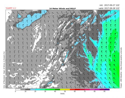
TERP WRF model forecast of 10-m winds for 8AM Thursday (Source: Trowal UMD)
Tomorrow (Thursday)
Thursday will be blustery and milder than the last two days. We will see clear skies again tomorrow, but temperatures will struggle to get out of the upper 70’s. A cold front should be move through during the day. This should help lower our humidity and usher in some more refreshing air mass. Expect breezy conditions with winds out of the northwest at 10 to 15 mph. We may see some gusts upwards of 25 mph.
Tropical Update:
Maria has regained its hurricane status off the coast of North Carolina. However, it will soon weaken back into a tropical storm. The cold front affecting our area will help push the storm out over cooler waters, which is good news for the East Coast. The North Carolina beaches will have to contend with some high surf and storm surge. The worst of Maria’s winds and rain should remain offshore.
As for Lee, that storm remains a Category 3 hurricane. It should track well east of Bermuda into the waters of the Northern Atlantic with no impacts for the East Coast of the US.
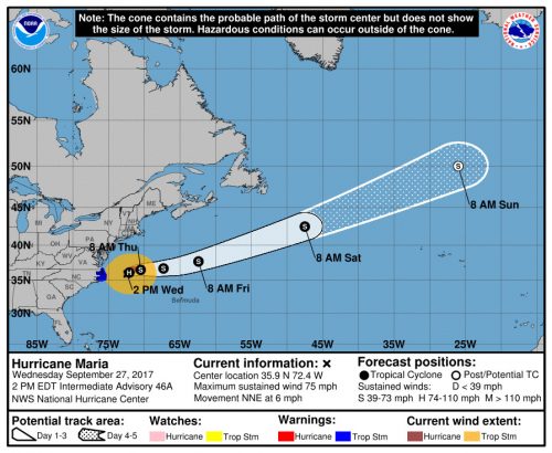
Forecast track for Hurricane Maria as of 2PM EDT (Source: National Hurricane Center)