
Winter Storm Warnings (pink shading) and Winter Weather Advisories (Purple) issued across the Baltimore-Washington areas (via NWS)
Everyone is bracing for the first major snowfall of the season! Most of you will be seeing a lot of snow and some may wake up to a disappointment. This depends on the critical rain/snow line which has been fluctuating across the I-95 corridor in the latest model updates. This storm is tricky here! So, if you are rooting for a lot of snow, then you want that rain/snow line to shift further south of DC. This will push the rain and sleet further south and allow more snow to push in. If you want mostly rain/sleet (barely any snow), then you want it to shift further north of DC so it can push the bulk of the snow to the North (away from the area).
Winter Storm Warnings are still in effect for locations north and west of Washington, D.C. from 7 pm tonight to Tuesday 2 pm (see pink color in image above). Additional locations along the I-95 corridor have been included in the warning. The Warning indicates these areas are expected to get severe wintry weather which includes significant snowfall totals that will affect travel. These areas could receive anywhere from 4-8 inches of accumulating snow, with higher amounts in far north and west Maryland.
Prince Georges County, Anne Arundel County and a few locations in Virginia have now been downgraded from a Winter Storm Watch to a Winter Weather Advisory (purple color in image above) from 7 pm to Tuesday 2 pm. The rain/snow line will hover along these areas (or shift slightly north) and produce mixing (snow/sleet) which will cut off snow totals. Snow and sleet accumulations are expected to range from 2 to 4 inches in these regions.
Here is our new snowfall forecast map:
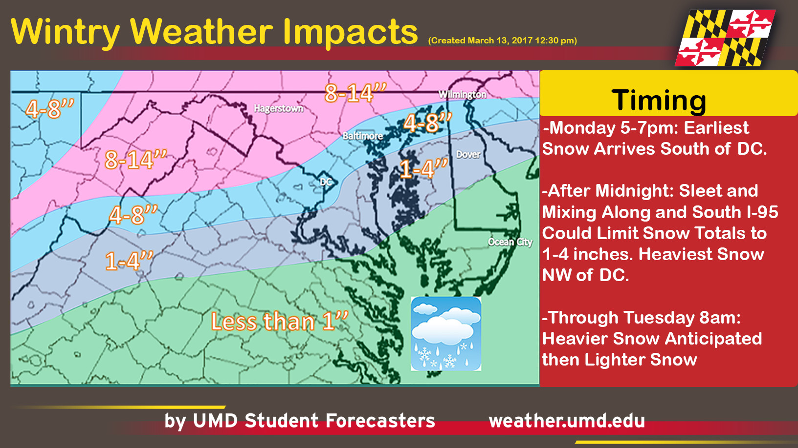
Snowfall Map created by our very own UMD Forecaster Doug Kahn
Here is the most likely Snowfall map issued by the National Weather Service:
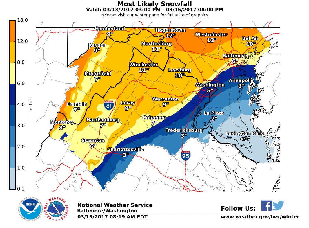
Most likely snowfall accumulation totals from 3 pm through Tuesday 8 pm (via NWS Balt/Washington WFO)
Overall, the entire area will experience cold and blustery conditions. We’re talking 10-20 mph winds with 30+ mph wind gusts for locations in the Winter Weather Advisory zone. 5-15 mph northeasterly winds up to 20+ mph in the Winter Storm Warning zone. Damaging winds can produce blowing snow and make conditions worse during a heavy snow event.
What’s Happening Now?
First off, it’s important to note the high uncertainty involved with this storm. The storm hasn’t formed just yet. But, we are still tracking two low-pressure systems that will come together and create our big coastal nor’easter storm (Note: low-pressure systems are associated with unsettled weather such as rain/snow). One storm system, currently located over the southern Illinois, will travel east and head into the DMV area later this evening. The other low is situated over northeast Florida. This system will travel up the coast and merge with the pre existing storm that’s coming from Illinois. The impact of the two storms will create our nor’easter winter storm.
(Timing) Monday 5:00 pm – 11:00 pm:
The storm is expected to arrive between 5 pm – 7 pm for locations further south of the District (purple). Areas across Virginia, DC, and around Northern Maryland should expect the earliest snowfall between 7pm and 9pm. Western Maryland (west of I-81) should see snowfall between 9pm and 11 pm. Please see image below for details.
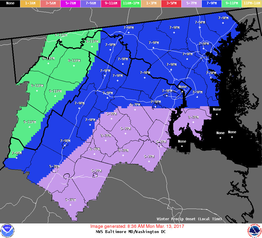
Expected arrival times for snowfall (via NWS Balt/Washington WFO)
Tuesday 1:00 am:
According to this afternoon’s GFS model update, the storm will usher in sleet and mix in the DC area and across Virginia (pink color on map below). This model has situated the rain/snow line right across the District. Therefore, parts of Prince George’s County and parts to the south and east will see some rain/sleet mixing in around this time period. Please try to avoid early morning travel during the overnight hours as snowfall intensity is expected to increase throughout the morning.

12Z GFS 6-hour precipitation Rate (via Tropical Tidbits)
We decided to include another model. The NAM 4km model (see pink color image below) is predicting the mix and sleet to last from Tuesday 1 am to 7 am. The sleet/mix line has been pushed further north and west of DC (just east of I-81). If this is the case, then this can really hurt snow totals! Also, this model is ending the storm much earlier than the GFS model.
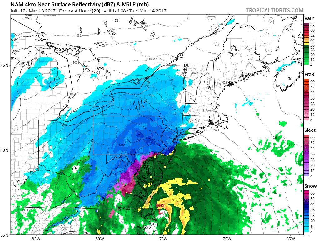
NAM 4km model displays sleet/mix around 3 am (via Tropical Tidbits)
Tuesday 7:00 am – 1:00 pm:
The coastal low will travel further up the coast and produce the heaviest snowfall for Baltimore, DC, and Northern Maryland. This could impact the early morning commute. The storm will wrap up before noon and snow intensity will lighten up rather quickly.

12Z GFS 6-hour precipitation Rate (via Tropical Tidbits)
Tuesday 1:00 pm – 7:00 pm:
The storm will push North and impact the Northeastern states. This will leave only light flurries for the DMV region through the remainder of Tuesday.

12Z GFS 6-hour precipitation Rate (via Tropical Tidbits)
Delays and Cancellations:
There are no reported closings for UMD just yet. Check out our 5 pm Evening Update Forecast for new information. Follow our twitter page @UMD Weather for more quick updates. Metro Access Bus Service will be suspended at 4 pm this evening.
Storm Impacts:
Significant snowfall totals (6+ inches) are expected with the heaviest amounts north and west of the District. There is still HIGH uncertainty on the exact location of the rain/snow line. Any areas that receive a mixture of snow and sleet (or just sleet) could still experience dangerous impacts. This is dependent upon nearly subfreezing temperatures. Heavy wet snow could knock out power lines and break tree limbs.
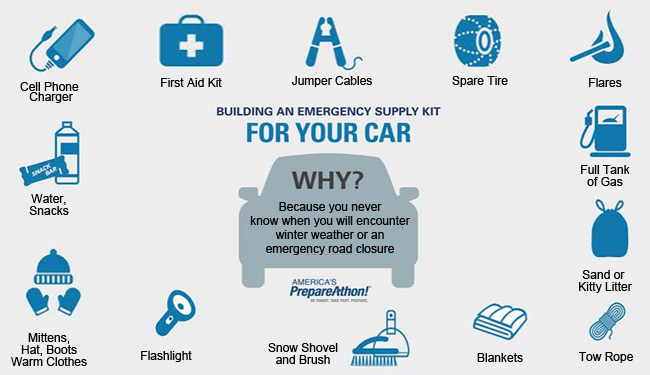
How to Prepare:
Make sure you plan and head to the grocery store before supplies run out (especially if you live North and West of DC). Other things to include: batteries, water bottles, and a wireless radio. Also, keep your cell phones charged and check back to UMD Weather for updates (You can follow us on Facebook, Twitter, or check our website).
Winter Safety (via NWS)
(Written by UMD Forecaster Aisha Murphy with Contributions from UMD Forecaster Cody Snell)