
The National Weather Service Baltimore Washington Forecast Office has just issued a Winter Storm Watch from Monday evening through Tuesday afternoon of this week. The storm could dump 5 or more inches of heavy wet snow within a 12 hour period. Potential storm impacts include power outages, broken tree limbs, slippery conditions, and messy roads.

National Weather Service has just issued Winter Storm Watch for the Baltimore/Washington area (via NWS Balt/Washington)
Which locations will be getting snow on Monday and Tuesday? How much snowfall can we expect? Well, all eyes are still on the potential set-up for Monday’s developing Nor’easter. We are tracking two systems. One low will be approaching the mid-Atlantic region from the Mid-West. Another developing low-pressure system will track along the coast. It will usher in a chilly northeasterly flow of 10-15 mph winds with up to 25 mph gusts. By Tuesday morning, these two systems will merge and produce impactful wintry weather for the Northeast region. Keep in mind there is still a lot of uncertainty for snow totals and the positioning of the storm. The uncertainty leaves behind low confidence for the exact position of the rain-snow line within the DMV area. The position of the rain/snow line could shift more snow south and east of DC or it could shift more rain and mix north and west of DC.

GFS forecast displays positioning of the low-pressure system and precipitation type across the mid-Atlantic (via Tropical Tidbits)
Tuesday Morning: Now, here’s when we will face the greatest potential for heavy snow. By 7 a.m., the GFS predicts heavier snowfall patterns for locations west of Washington, DC and throughout most of Northern Maryland and Virginia. The model positions the low just off the coast of Eastern Maryland. As you can see, the rain-snow line extends in a slight southwest-northeast direction just south and east of the District. Portions of Prince Georges County and further east could experience less snow and increasing chances for rain showers.
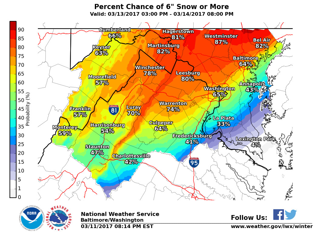
The National Weather Service predicts that there will be a 65% chance of 6 inches of snow or more for the DC/metro area (see image below).

Most likely snowfall accumulations for Monday night through Tuesday could accumulate up to 6-7 inches in the DC/Baltimore region with higher totals north and west (via NWS)
Please continue to follow @UMD_Weather for updates!