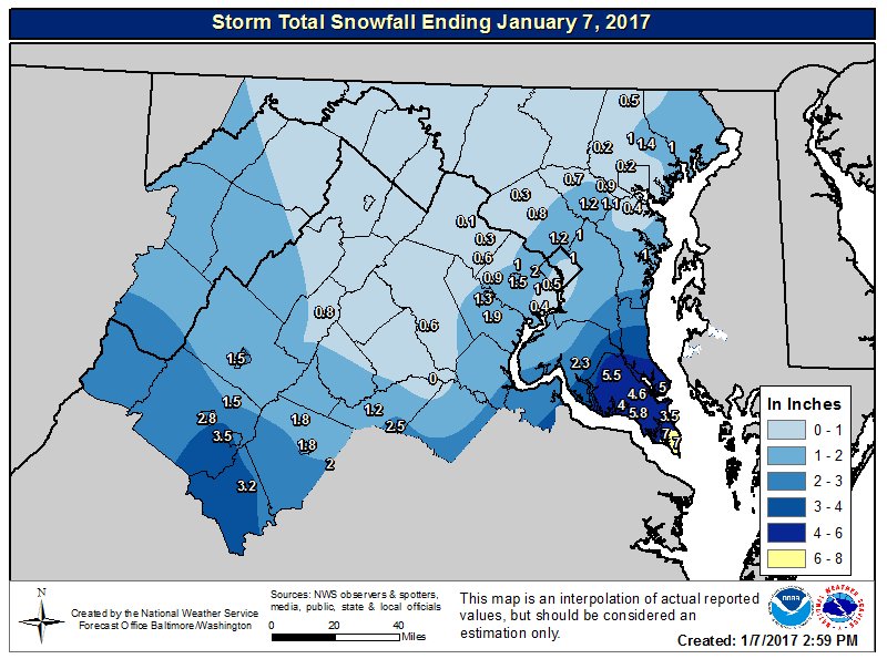
This past Friday and Saturday’s snowstorm brought us our first measurable snowfall of the 2016-2017 winter season. The storm had the classic Nor’easter elements. But, this system tracked more south and east than usual…opening the door for cold and dry air from the north to compete with the moisture this storm brought us. As a result, we observed higher snow totals to south and east of the District (see image below). Following the snow, we took in another dose of cold, arctic air that will stick around until tomorrow. Rain will impact us before we experience a mid-winter warm-up later this week.

NWS Storm Total Snowfall Ending January 7, 2017. Higher snow accumulations south and east of the District (via NWS Balt/Washington WFO)
Through Tonight:
As low clouds thicken tonight, today’s pleasant but cold weather will transition to cloudier conditions. Expect temperatures to drop into the teens for the majority of the DMV area along with some low 20s possibly near the bay and/or within the DC area. Southerly winds will stay calm around 5 mph. So, wind chill tonight will not be too much of a factor.
Tomorrow (Tuesday):
Increasing winds out of the south/southwest will help rise temperatures into the mid to upper 30s tomorrow. Overcast skies lingering throughout the day might prevent temperatures from boosting any higher. Wind speeds should be around 10-15 mph along with a few gusts approaching 20 mph. A weakening cold front passing through our area should give us some showers after sunset.
(Featured photo courtesy of: NWS)
