
Hermine Gets Her Act Together
A large area of disturbed weather with embedded convection, known as an African Easterly Wave (AEW), has had the attention of forecasters and armchair weather weenies for the better part of the past 10 days. As its name suggests, systems such as this originate as thunderstorm complexes over West Africa and move westward across the tropical Atlantic, where they can potentially develop into tropical depressions, and eventually hurricanes, if conditions are favorable. Until yesterday, the convection of this AEW has appeared ragged and unorganized, with multiple low pressure centers appearing at times as it passed just north of the Greater Antilles into the eastern Gulf of Mexico.
Over the past couple of days, convection has begun to fire more vigorously over a better-defined surface low. Yesterday, Tropical Storm Hermine was finally born, after NOAA aircraft “Hurricane Hunter” reconnaissance missions found sustained surface winds near the center of tropical storm strength (>39 mph).
This morning, Hermine who was previously playing coy with forecasters has really started to get her act together. Compare the visible satellite image of Hermine at noon today (Fig. 1), with her at 7 am this morning (Fig. 2). In the latest image, a comma-shaped band of bright white clouds has wrapped around the storm center, whereas earlier this morning the bright white clouds remained in a solid blob to the east of the center. The bright white clouds indicate deep, tall thunderstorms that are being fueled by the bathtub-warm (86 deg F) sea-surface temperatures below. The intense updrafts generated by these thunderstorms cause the moisture-rich air to cool and condense, releasing massive amounts of latent heat energy into the atmosphere-in essence, the “jet fuel”, that the storm’s engine can use to power its swirling wind circulation. This process can only happen efficiently, however, when the convection organizes in a circular eye wall around the center – and this appears to be happening now. A hint of an eye seems to be developing as well.
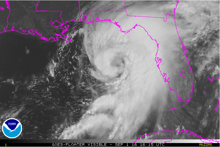
NOAA GOES visible satellite image for Tropical Storm Hermine, valid 12:15 pm EST today (Fig 1) Via NHC
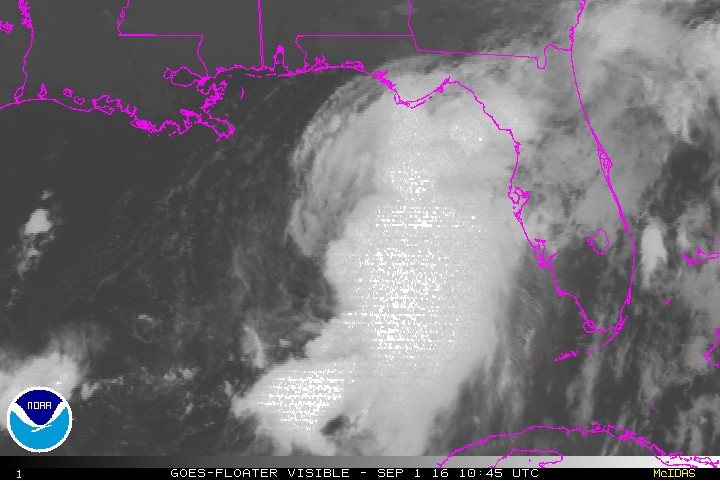
NOAA GOES visible satellite image of Hermine, valid 6:45 am EST today (Fig 2) Via NHC
And check out the observations being reported by an Air Force reconnaissance plane that is flying criss-cross legs through the storm, as of this writing (Fig 3). One thing to notice is that, despite the increasing organization of the storm’s inner-core region, the storm is still pretty asymmetric. The strongest winds are concentrated to the south and east of the center, where the tropical moisture is deeper and the thunderstorm activity is more widespread. These winds are also stronger than the surface winds, since they are sampled at flight level (about 800 mb) away from the frictional drag generated by the churning seas below.
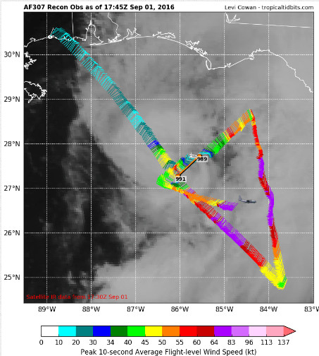
Air Force aircraft reconnaissance mission observations for 1:45 pm EST today (Fig 3) Via Tropical Tidbits
What Took Hermine So Long to Become a Hurricane?
So why is Hermine becoming organized just now? For at least a week, the storm’s AEW precursor has been traveling over sea surface temperatures warm enough for tropical cyclone development. The process of tropical cyclogenesis – the transformation of a tropical wave into a tropical storm with a closed, intensifying circulation, is a complex one and a big research effort has been devoted in recent years to better understanding it. But looking back on the storm’s AEW origins, the three main factors preventing the storm from intensifying up until now have been:
- significant vertical wind shear (winds increasing with height), which tends to prevent the convection from organizing above the center
- midlevel dry air being nearby and periodically being pulled into the circulation, suppressing convection
- the inflow from the southeast side (which is normally the source of deepest moisture) being dried out by down sloping off the tall mountain ranges of the large Caribbean islands (Cuba and Hispaniola in particular)
Today, the vertical wind shear has relaxed to 10-15 kt, and the approach of a mid-upper level trough over the eastern US is giving the storm a better upper-level outflow channel to its north. The outflow acts like a huge “vacuum cleaner,” sucking air out from above the inner-core. This improves the efficiency of the hurricane’s internal heat engine by reducing the work spent on lifting air in its thunderstorm updrafts, enabling it to better convert the latent heat energy to kinetic energy-which means stronger swirling winds (and yes, the term “swirling winds” is used throughout the scientific literature, probably because it is at least slightly more poetic sounding than the alternative term “primary circulation”).
The National Hurricane Center (NHC) official forecast (Fig. 4) has Hermine strengthening to Category 1 Hurricane intensity and striking the Florida Gulf Coast “Big Bend Region” tonight with 75 mph winds, flooding rains, and destructive storm surge of up to 8 feet locally. This will be a serious situation for that area, and it would end Florida’s historically unprecedented 10-year period with no hurricane landfalls anywhere on the state’s coastline. If the storm had more time over open water, it would likely continue to strengthen, given the favorable conditions right now.
The longer-term impacts of Hermine are much more uncertain. All short-range computer model guidance is an agreement in the storm being steered northeastward by the mid-level trough. The storm will also begin to transition into an intense extratropical low as it interacts with the through, which would keep the threat of flooding rains and potentially damaging winds along and to the east of the storm center as it transits the coastal southeastern U.S. Thus is because even though the storm will travel over land, and lose its heat source from the ocean, the strong upper-level winds associated with the tough will inject an extra “boost” of energy into the storm.
Where is Hermine Headed?
Yesterday, the majority of the models brought Hermine ‘s remnants further west, inland from the coast, over the central Carolinas and over the Chesapeake bay. A track such as that could have brought tropical-storm force winds and rains in excess of 4 inches (plenty enough to generate flash flooding) to the DC metro area this Saturday. However, beginning with last night, the models have been trending the storm to track farther to our southeast. This may be due to the fact that yesterday’s models all initialized the storm from position further west, which may have been a temporary wobble.
With the latest track guidance, our area would see much more of a glancing blow from Hermine (Figs. 4 and 5). Still, it is far too early to say with certainty that we will not see impacts from Hermine in the DC area, especially on Saturday and Sunday. The longer-range synoptic weather pattern is quite murky right now. Some of the guidance is hinting that the mid-level trough will lift out away from the storm and the wind shear will relax by Sunday, when the storm center should be located a few hundred miles east of us over the Western Atlantic. The sea surface temperatures over that area are abnormally warm, so it is even possible that Hermine’s remnants might start re-acquiring at least some tropical characteristics! Check out this morning’s GFS model run forecast for Sunday morning, which shows quite the monster of a storm (sub-1000 mb low) sitting east of the Delmarva, with the potential to lash the Maryland and especially New Jersey beaches with gale-force winds and significant storm surge (Fig. 6).
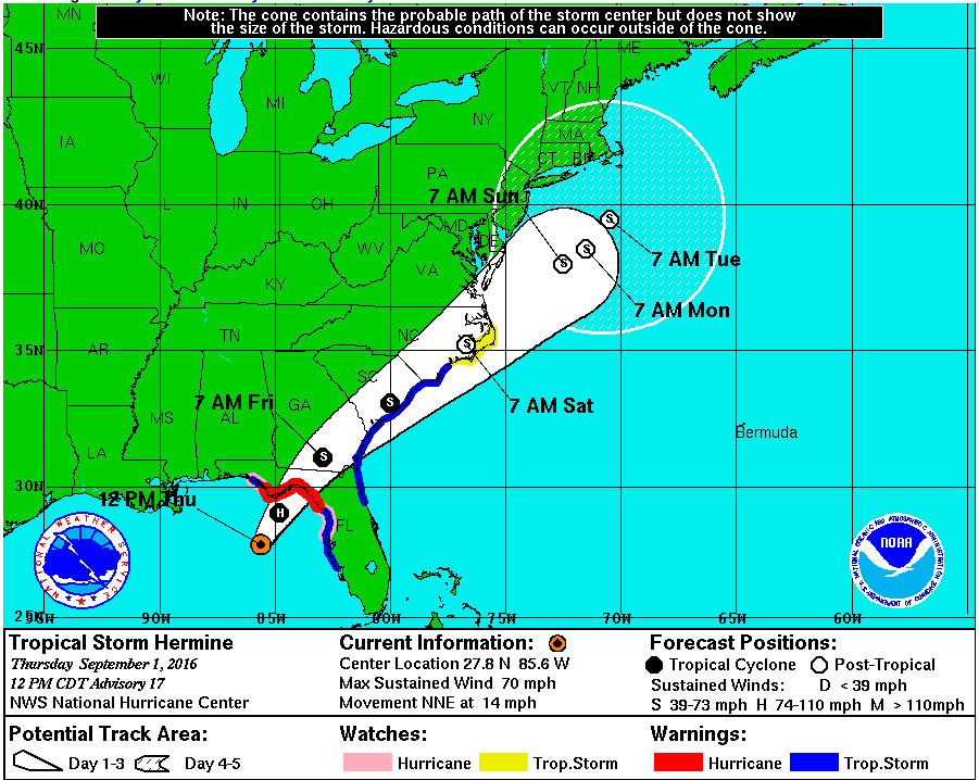
Latest NHC forecast track for Hermine (Fig 4)
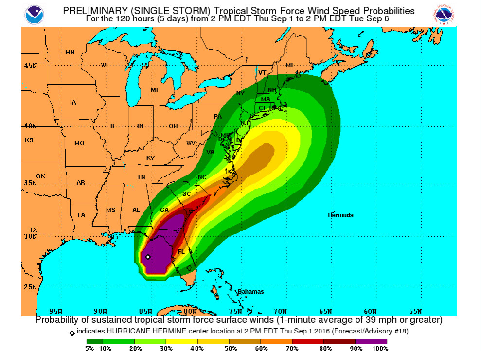
NHC tropical storm force wind strength (> 39 mph) probabilities for Hermine from their 2pm EST forecast today (Fig 5)
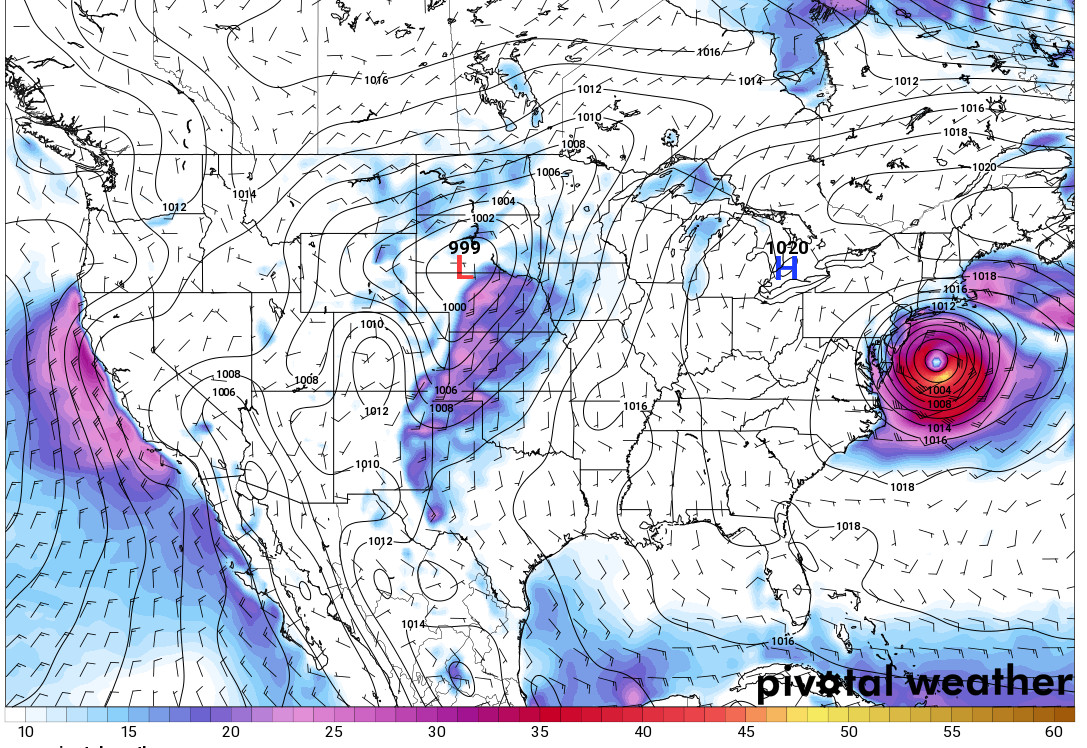
GFS model 72-h forecast (valid 8 am EST Sunday Sep 4th) of surface pressure (mb) and 10-m winds (kt) (Fig 6)
The bottom line with Hermine is this. It will almost certainly be a significant, potentially life-threatening event for parts of the Florida Gulf Coast, and also perhaps the coastal parts of Georgia and the Carolinas, depending on the track. For us, the impacts could range from a cloudy period Saturday and Sunday, with perhaps a few showery rains, to an all-out heavy soaking rain happening sometime over that period, with localized flooding possible in the usually susceptible low-lying areas. At the moment, damaging winds here appear highly unlikely, but we can’t rule that out quite yet. If Hermine’s remnants do end up stalling over the Atlantic to our east, areas to our northeast (i.e. coastal parts of New Jersey, New York and New England) would likely be on the stronger side of the low and more at risk for flooding and high winds. If you plan to head up that way for the Labor Day weekend, be sure to play very close attention to the latest forecasts.