
 HEAT ADVISORY
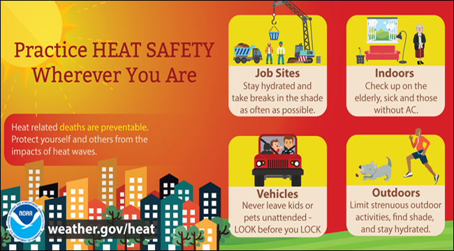
You might want to adjust your thermostat to a cooler setting for the next few days because the mercury is about to get real high! An active heat advisory alert has been issued to areas along and east of I-95 and will end around 8pm as we lose some daytime heat. The threat of dangerous heat will impact most people who are outdoors. Necessary precautions for preventing heat illnesses include the following: reduce outdoor work and exercise, drink plenty of water, limit your time outdoors, don’t leave anyone in the car at all, keep your pets and children indoors if possible, and try to avoid wearing dark-colored clothing. According to the CDC, muscle cramping might be one of the first signs of heat-related illnesses that may possibly lead to heat exhaustion or heat stroke. If you or someone else does happen to experience any of these signs and symptoms below, then please seek immediate medical attention.
SHORT RANGE FORECAST:
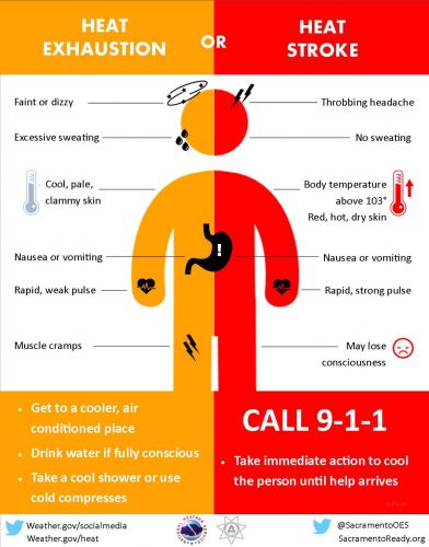
Courtesy of the NWS. Heat related illness symptoms and signs.
So, what’s causing the oppressive heat? Warm winds from the south are transporting moist and hot air into the mid-Atlantic. This influx of heat and moisture will cause higher humidity and temperatures for the next couple of days. This morning started off with mostly clear skies. The lack of clouds has allowed sunshine to heat things up rather quickly with 80 degree temperatures this morning. With current dew points in the mid-70s, the combination with hot temperatures indicates that it will feel much hotter and will probably cause some hair to frizz up! Also, let’s not forget to mention that today will be a sweaty day for those who are hanging outdoors. Some stray showers and thunderstorms might develop this afternoon. Models reveal that the earliest precipitation could possibly occur around 2pm with some isolated thunderstorms likely occurring later during the late evening commute. Since the heat advisory is effect, overnight temperatures won’t cool to anything less than 70 degrees. Friday will be a repeat of today with high temperatures in the lower 90s. The southerly flow of warm air will generate hot temperatures again. Humidity will continue to be a factor and will max out heat indices near 100. An approaching cold front that pushes through on Friday night will stir up some light precipitation and thunderstorms for the weekend. On Sunday, seasonably warm temperatures and humidity will move into the region and persist through the start of the work week.
THURSDAY
Today will be hot and oppressive. Partly cloudy to mostly sunny skies give way to hot morning and early afternoon temperatures. Maximum temperatures will be in the mid-90s while some areas closer to the District might exceed 95. Southwest winds will amp up the humidity resulting in heat indices near 105. A warm and moist air mass could lead to early afternoon/late evening thunderstorms. As more clouds move in tonight, there will be a slight possibility for a shower or thunderstorm to occur north of Washington, D.C. mainly after 10pm. Storms won’t be too severe but heavy rain is expected for areas that get major storm activities. Overall chance of rain is 20%.
FRIDAY
A mix of clouds and ample sunshine will start the morning off mild with temps in the upper 70s to low 80s. Some areas, especially near the District, will probably have a slight risk for thunderstorms and showers during the evening and should dissipate overnight. High temperatures will be in the lower 90s and heat indices will range from 100-105.West winds at 5-10mph will give a warm breeze throughout the day. Friday night will be warm and seasonably mild. Southwest winds shift to a northeasterly breeze overnight. Lows expected to be around 70F.
SATURDAY
A cold front moving in place will turn partly cloudy morning skies into a mostly cloudy state before storms roll in. There is a 40% chance of rain and thunderstorms throughout the day and into the afternoon. Some areas might get more severe storms than others. The potential for heavy is in effect. Evening high temperatures are around the low 90s. Forecast lows are in the low 70s.
SUNDAY
It will be warm and pleasant with mostly sunny skies. Very slight chance of an isolated shower. Although it will be a few degrees cooler, the humidity and heat will stick around. High temperatures will approach the upper 80s and lows will be in the low to mid-70s.