
The Delmarva region just accepted a warmer than usual welcome from this year’s first heat wave of the summer! Due to a very moist air mass, high humidity levels (above 80%) will spike hazy, hot and humid conditions for majority of the forecast area. High temperatures will produce heat index values near 100F. It will FEEL much more like 100 or so degrees instead of the forecasted 90-degree temps.
The combined heat and moisture has already induced a code orange air quality alert on Thursday for areas mainly north and east of the DC metro area. Individuals with respiratory or heart problems, including young children and the elderly, should be aware of the risks of being outdoors for long periods of time. The best time to exercise is during the early morning hours just before sunrise. Maximum high temperatures will become seasonably above average and approach the mid to upper 90s throughout the rest of the workweek along with possible chances of afternoon storm activity.
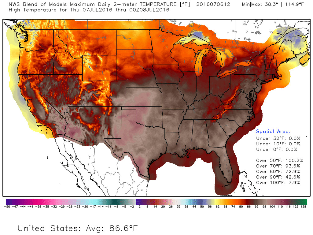
Courtesy of Weather.graphics Blended NWS model models display above average temperatures and a heat wave for the DC/VA/MD region
Thursday AM
Midnight temps only fell to the upper 70s in the suburbs (80s in the district)! High humidity and dew points in the low to mid 70s will persist into the morning. For those taking an early morning jog around 6am, you will most likely experience a thick yet hazy mass of air that will be feel uncomfortable to inhale if exercise becomes too rigorous as the morning progresses. With overnight temperatures barely dropping below 75F, the early Thursday morning commute will accompany humid 80-degree temps by 8am. 9am temperatures near 82F will already feel close to 90 degrees. Periods of clouds and sunshine will occur along with rapidly increasing temperatures. Counties surrounding the capital beltway will reach up to 90F degrees just before the noon lunch hour. We won’t really rely on winds to cool us down since light and variable south/southwest winds will advect warm air from the southern states and into the Delmarva corridor.
Thursday PM
90-degree temps just before noon will finally creep just a few degrees higher toward the mid 90s by 2pm. The midday heat index will range from 96-100F. The commute home may be little damp but not a washout. Heat and humidity might provide conditions favorable enough for an evening isolated thunderstorm or shower. Models are showing future storms rolling through areas south of DC and into southern Maryland by the late evening. Some parts of the storm may be severe as it approaches southern Maryland. A stray shower may swim through the northern half of the region near College Park.
Friday
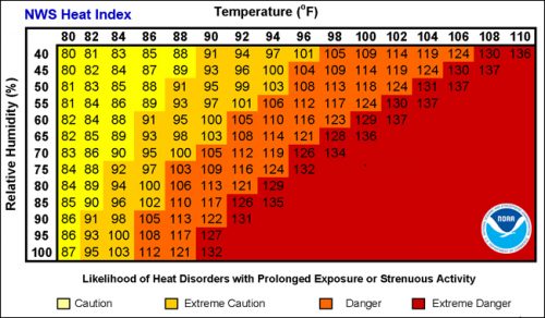
NOAA NWS Heat index calculator chart
Good news: Humidity plummets and the heat wave nearly approaches its departure. Bad news: Friday is still just another hot day of the week before things cool down over the weekend. Yes, high temperatures will peak around 95F making the heat index feel pretty much the same as Thursday (nearly approaching 105F). Keep outdoor activities limited because it will feel oppressively hot and muggy. It will be partly cloudy during the day before more incoming clouds take over later in the evening. Low pressure could provoke some evening thunderstorms. Overnight lows remain mild in the mid-70s.
Saturday
Saturday will be our 10th day over 90 degrees this year. Fortunately, an approaching cold front will cool us down a bit and the humidity will decrease as well. The approaching cold front won’t actually be expected to bring in cold air (since it is summer), but it will force in drier and milder air temperatures near the upper 80s. Thundershowers are possible but the risk applies to the wee morning hours. Most of the weekend day will be clear and beautiful with lots of sunshine!
Sunday
Say goodbye to our tremendous heat wave and hello to a more seasonable flow of air. Sunday starts off cool and dry with mild temps ranging from 85-90F. High pressure moving in will put an end to Saturday’s cold frontal system before the end of the day. This will keep us mainly clear and sunny just before the humidity increases back up into next week. High temps: 86-87. Low temps: near 65 in the suburbs. near 70 in urban areas.