
This week will mark the 5 year anniversary of the historic April 2011 tornado outbreak that wreaked havoc over a 3 day period through 21 states. April 27th’s 317 fatalities were the most single day tornado deaths in the US since the vaunted Tri State outbreak in March of 1925. In what seems like a cruel twist of fate, the atmosphere is once again locked and loaded, ready to deliver another round of destructive weather.
While the areas expected to be affected tomorrow won’t be the same locations terrorized back in April of 2011, the central plain states are no strangers to tornado related devastation. In 2013, when two powerful twisters tore through the Oklahoma City suburbs of Moore and El Reno, taking 30 lives and causing hundreds of injuries.
Setup/Background
As with most severe weather outbreaks, a strong upper level storm center will move into the region late tomorrow afternoon. This key ingredient will provide very large-scale instability, which we can think of as anomalously cold temperatures aloft in the mid levels (10,000-18,000ft up). Why is a cold upper air environment important? Well remember, warm air always rises. And if a warm parcel of air gets pushed upwards to an area with cold surrounding temperatures, it will continue to rise uncontrollably for thousands of feet. Picture those big towering thunderclouds that we often see with severe weather outbreaks.
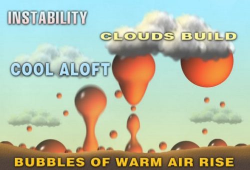
Diagram of upper level instability
Of course, instability alone is not the only variable needed for a tornado outbreak and not all supercell thunderstorms result in tornadoes. In fact, we don’t know for sure (great research question!) why some have tornadoes and others don’t. But we do have a pretty good idea of the parameters favorable for a tornado outbreak
We’ve already mentioned 1.)Upper level instability. But additionally, we need 2.)warm and moist air at the surface which gives the air at the surface a nice kick in the but, forcing it upwards. Lastly, and perhaps most important, we need 3.) vertical shearing, which probably sounds a lot more complicated than it really is. Shearing is the result of wind velocity or direction(or both) significantly changing with height. For example, if we had a wind speed of 10 mph from the west at the surface and a 60 mph north wind at 5000ft, we would anticipate a considerable amount of wind shear.
Why is wind shear important? Check out the schematic below. Tornados need significant low-level wind shear (directional or velocity) in order to form.

The role of wind shear in tornado development
Today’s Set Up
We will find all of the key ingredients in place this evening in the central plains.
1. ) Instability aloft

500mb Heights and Temperature at 8pm on Tuesday 4/26
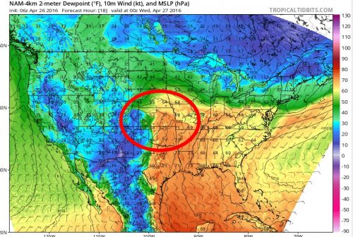
2. Warm and moist air at the surface
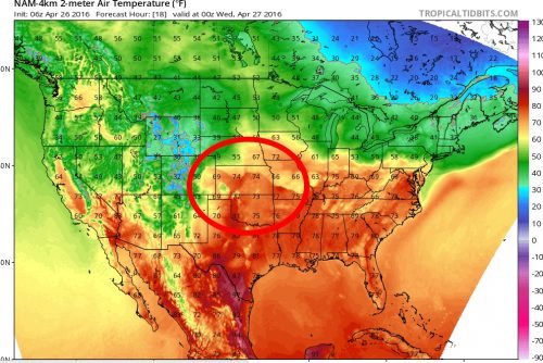
Surface temperatures and dew point at 8pm on Tuesday 4/26
3.) Strong wind shear
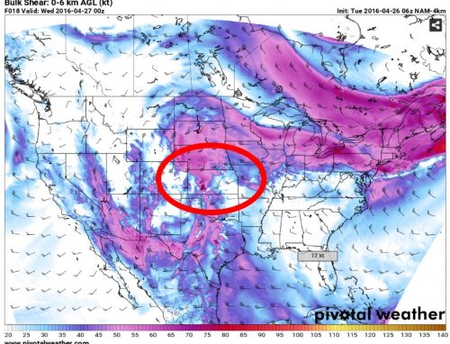
Wind shear at 8pm on Tuesday 4/26
You will notice that all of the significant tornado severe weather parameters align in the area marked by the red circle. It should come as no surprise then that the SPC (Storm Prediction Center) has this region with the highest probability of severe weather and tornado activity today.
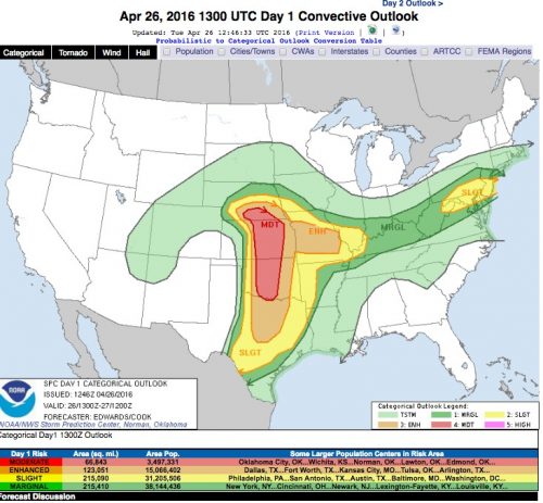
SPC Convective Outlook for Tuesday 4/26
I don’t think the severe weather today will approach the severity of the aforementioned 2011 and 2013 events. Model trends over the past 24 hours have backed off in the amount of low-level wind shear that will be present today. There is still plenty of juice for strong and damaging thunderstorms with embedded large and powerful tornadoes. However, the lack of low-level shear should limit the chances of long track wedge tornadoes that typically cause the most widespread death and destruction. Nevertheless, it will definitely be a dangerous day for the folks in the central plains.
Postscript
- A few postscripts. Those with a keen eye may have noticed the mid-Atlantic is identified by the above SPC map as a region with a slight risk for severe weather today. Some strong and isolated thunderstorms could affect the area late this afternoon with the passage of a cold front. Nothing like the weather the central plains will see today, but still worth keeping an eye on regardless.
- If you would like to read more about the 2011 tornado outbreak, I highly suggest the book What Stands in a Storm: Three Days in the Worst Superstorm to Hit the South’s Tornado Alley by Kim Cross. A great non technical hour by hour analysis of the chaos those storms brought to Alabama and Mississippi. One of the better weather books I’ve read in a while.