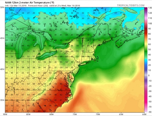
Over the past week or so we have seen the weather shift quite drastically from chilly winter weather to very pleasant summer-like weather to now more of a spring-like showery pattern. Over the next week expect this rollercoaster like pattern to continue. After a few days of dreary showery weather early this week some minor clearing is possible on Wednesday with temperatures warming above average. Below is an image from the 12z NAM computer model showing temperatures in the upper 60s to near 70 across the region tomorrow at 5pm.
This warmth will be short lived as yet another system pushes into the region Wednesday afternoon bringing back showery weather and cooler temperatures through Thursday. Not much rainfall is expected from this system but it will be enough to make things dreary for a period of time. Skies should then clear out for Friday but cooler weather will have moved in with highs likely only in the upper 50s. The clear skies should continue on Saturday but with even cooler air moving in leading to temperatures struggling to reach 50.
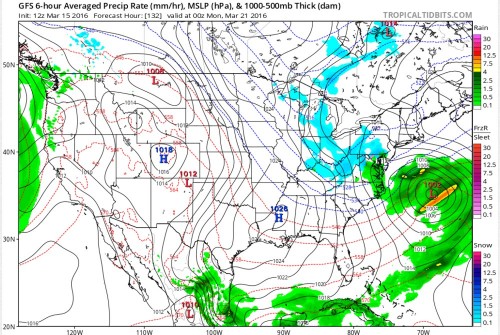
Yet another storm system will approach the region on Sunday bringing unsettled weather with periods of rain Sunday and Monday as the cool air sticks around. There is still some uncertainty with this system as earlier model runs had shown the possibility of some snow mixing in with this system but it does now appear that it will most likely be warm enough in our region to all be rain. Areas further north and west into Pennsylvania and West Virginia, however, could be dealing with a late shot of winter weather at the end of the weekend. Below is an image from the 12z GFS computer model run this morning showing the late weekend storm with some light snow(shown in blue) across central Pennsylvania and West Virginia.
After the storm system moves out early next week we should see a return to southerly flow and warmer conditions with temperatures possibly back into the mid 70s midweek before another storm system rolls through later in the week. So the quick and dirty is that we are in a very active weather pattern with large temperature swings and frequent storm systems likely to impact the region over the next week or so.


