This week will feature a mixed bag of weather, starting with spring like weather and ending with a possibility of snow. Today is the start of the meteorological spring and which runs through the months of March, April, and May compared to the astronomical spring which does not start until the spring equinox on March 20. Unlike many years, the first day of meteorological spring will feel more like May than March with unseasonably warm temperatures and even the chance of thunderstorms.
Tuesday’s Forecast
Highs for today will be in the mid 60’s, which is over 15 degrees above average for this time of year. These warm temperatures are thanks to the southerly wind flow ahead of the area of low pressure in the Ohio Valley advecting warm air from the south. This low pressure system and the associated cold front will push through our area tonight and will bring colder air into our region and some isolated rumbles of thunder.
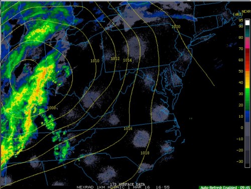
The current radar image above shows a line of heavy showers and thunderstorms along the cold front. These showers and thunderstorms will continue to advance towards our area through out the day and move in after 9 PM tonight. While the conditions for severe thunderstorms are not present, some thunder and lightning can not be ruled out. Rainfall at this time does not look significant, with most of the model guidance suggesting less than a half of inch of rain will fall. After the cold front pushes through winds out of the west will help bring in the colder air mass behind the front.
Snow For The End Of The Week?
The cold air in the wake of the front passing through on Tuesday tonight, will make Wednesday and Thursday more winter like than March. Highs for both days will be in the low 40’s and lows over night will be below freezing, which are colder than normal conditions for this time of year. This cold air will help set the stage for the possibility of the light snow Thursday night into Friday morning.
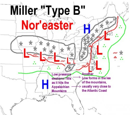
Before discussing the snow chances, lets quickly go over the types of coastal low pressure systems that bring snow to our area. The first type of coastal low is called a Miller A, which occurs when an area of low pressure strengthens as it moves north from the Gulf of Mexico staying close to the East Coast. Many of our regions biggest snow storms come from Miller A storms and these storms are more likely to give the Mid-Atlantic snow. For all of those hoping for a blizzard Thursday night, I am sorry to say that this storm will not be a Miller A type storm. The system impacting our area on Thursday night will be the second type of coastal low, creatively called a Miller B. This type of storm system is more complicated than a Miller A and occurs when an area of low pressure moves east through the Ohio and Tennessee River Valleys called the primary low while at the same time a coastal low begins to form off the coast of the Southeast called the secondary or coastal low. As the primary low moves east it weakens as it transfers its energy to the secondary low, which begins to strengthen and deliver snow to the regions north and east of the secondary low. During Miller B storms when the primary low begins to weaken the associated moisture and snow begins to diminish there is an area that does not see snow from the primary or secondary low pressure systems; this area is appropriately called the dry slot. Many times this dry slot forms at the same latitude as the DC metro area and has led to little to no snowfall for our area.

Schematic of Miller B Type Snowstorm.
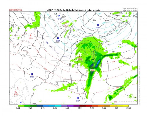
Unfortunately for those who want to see significant snow, the current weather models have the dry slot for Thursday night’s storm in our area. According to the 12z models on Tuesday the primary low will track near our area bringing some light snow with surface temperatures near 32 degrees during the over night hours after 10 PM Thursday into the early morning hours of Friday. The warm conditions from early this week will make the ground temperatures above freezing, which could cut down on accumulation of snow. During the day on Friday the secondary low will begin to strength off of the Delmarva Peninsula, however, it will be too far east for us to see any snow from it. Total snowfall accumulations at this time could be a trace to 2 inches for the immediate DC metro area with the possibility of slightly more North and West of the area.

The 12z TerpWRF showing the primary low east of our region bringing light snow with the secondary low forming off of the coast of Cape Hatteras.
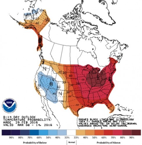
The long range forecast is hinting at above average temperatures first two weeks of March, which makes Thursday Night’s storm possibly the last snow storm of the wild winter season of 2015-2016.


