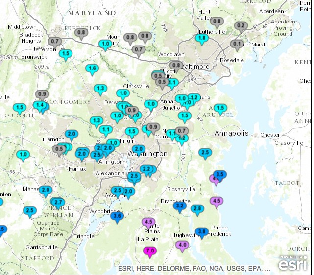
Snow has stopped falling for much of the DC/Baltimore area as of 3PM this afternoon. A general 2-4 inches fell in across the region, with some higher totals across south east parts of Maryland. Surface temperatures have been stuck in the 20’s all day, ensuring that whatever fell from the sky was going to be snow.

The stubborn cold airmass stuck at the surface will slowly loosen its grip this evening and overnight. In fact, the temperature on campus has risen to 29 degrees within the past few hours. Nevertheless, surface temps in the entire region are expected to remain below 32 degrees until around 1AM. Meanwhile, warm air will begin to penetrate into the upper atmosphere overhead, with 850mb (about 5000 ft up) temperatures warming above the freeing mark within the next few hours. Warm air aloft with cold air stuck at the surface sets the stage for a mixed precipitation event this evening.
Two crucial questions remain unanswered.
What form of mixed precipitation will fall, sleet or freezing rain?
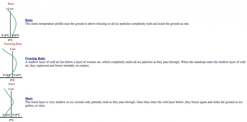
Between 4-midnight is our most vulnerable timeframe. Main low pressure system still centered over Mississippi, but will quickly begin to move to the north east tonight. Ahead of it, spotty precipitation will pop up along a stalled out warm front to the south. Warm air aloft over cold air at the surface means mixed precipitation, but what kind? Well, that depends on the depth of the layer of warm air. The image below shows the subtle difference between freezing rain and sleet. A shallow layer of cold air at the surface would result in freezing rain. A larger (higher) cold air mass at the surface would result in sleet.

Image courtesy of the University of Illinois at Urbana Champaign
Obviously, freezing rain is much more impactful than sleet and our current thinking suggests more freezing rain than sleet tonight. Any amount of freezing rain over 0.15 inches can start to cause significant problems. Which leads us to…
How much precipitation will fall before the complete changeover to rain?
There is no doubt we will changeover to rain overnight. As the main storm system gets closer, warm air will flood the region, warming us into the 40’s and even low 50’s tomorrow. Some heavy rain will accompany those warm temps, but what about the vulnerable period from 4-midnight?
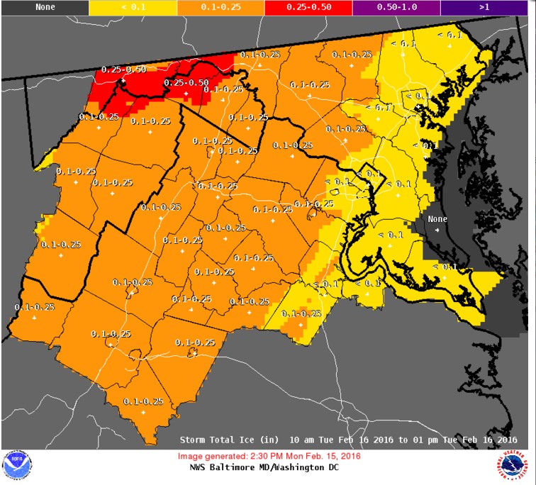
Precipitation will likely remain light in nature for most of tonight, which should hopefully reduce any substantial icing problems. We like the outlook that the NWS Sterling is sticking with:

Most if any icing issues should occur the the west of the DC/Baltimore area. However, it should be noted that short range models keep showing a potentially heavy band of freezing rain moving through the District right around midnight, just before the anticipated changeover to rain. Certainly something to keep an eye on.
In any event, we don’t expect substantial issues for tomorrow mornings commute. Several predawn hours of above 32 degree weather and a complete changeover to rain should limit travel complications in the metro areas. More travel problems are likely in the areas marked in orange above.
Bad news for those hoping that the University would be closed for a second straight day. Perhaps a delayed opening? Ultimately, we are not in charge of University closing decisions so we reserve the right to be wrong!
Stay tuned to UMD Weather Facebook and Twitter for more updates tonight.
