
At weather discussion today we discussed the cold airmass that currently is in place over the Mid-Atlantic that produced a daily record low temperature of -4 degrees F at Dulles airport last night, and why even though temperatures at 850 mb (roughly 5000 feet above sea level) are 10-15 degrees C warmer than those seen over Maryland during last week’s cold wave, last night was actually the coldest night of the year for many DC area locations. Why so? Ideal radiational cooling conditions–high pressure overhead, no winds, snowpack.
We also looked at the NAM, GFS, and ECMWF model solutions for the evolution of an upper-level shortwave trough currently passing over the desert southwest, which is associated with the southern branch (or subtropical) jet. All models agree on surface low formation in the Gulf of Mexico just south of Louisiana tomorrow afternoon, and the development of a precipitation shield, associated by the strengthening low, that spreads northeast into the southeastern states tomorrow night. The big question for us is: how far north with the precipitation shield spread? The 540 dm 1000-500 mb thickness line is forecast to sit near the VA/NC border during the evolution of this storm, so any precipitation that does fall in our area would be in the form of snow. The 12Z NAM and 06Z GFS runs spread light precipitation (maybe 0.01 – 0.1 in QPF) over our area late Wednesday night into Thursday morning, while the 00Z ECMWF from yesterday evening keeps us dry. As they currently stand, the NAM and GFS solutions would be a fairly low-impact event for us, even with the cold ground temperatures, due to the light QPF, with perhaps slightly higher impacts to our south over southern Maryland and central Virginia. This system bears watching, however, as the 12Z NAM and 06Z GFS have trended northward from previous runs, and several systems impacting us over the past few weeks have trended northward in the final 1-2 days from previous model runs. Here is the GFS solution for Thursday morning:
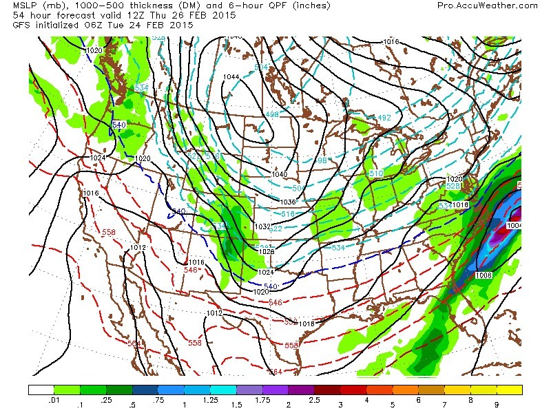
06Z GFS model forecast for 8 AM thursday Feb 26, showing light precipitation over College Park
Following the wednesday night/thursday morning system, cold temperatures return on thursday and friday with high temperatures struggling to reach the freezing mark, as a strong Canadian high pressure center builds in from the midwest. Bitter winds and even snow showers are possible thursday with the cold air advection.
Finally, we looked at the CPC 6-10 and 8-14 day outlooks, which continue to show high probabilities of below-average temperatures over the central and eastern states. The RRR (Ridiculously Resilient Ridge) over the far west continues to flex its muscle, as it has for a good part of the past 2 years, and send continued cold intrusions from the Canadian Arctic region to the central and eastern United States.